
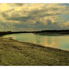
" Die Natur rund um Mont-Saint-Michel "
Ursprünglich war die Insel nur bei Niedrigwasser von der Küste zu erreichen. Um 1877 wurde dann ein Damm gebaut, über den eine Straße die Insel gezeitenunabhängig mit der Küste verbindet. Allerdings kann es durch Sturmfluten noch heute dazu kommen, dass die Insel vom Festland abgeschnitten wird.
Durch den Bau des Dammes, der die natürlichen Meeresströmungen unterbricht, versandet die Bucht immer mehr. Zudem wurden jahrhundertelang Küstengebiete trockengelegt, um Ackerland zu schaffen. Durch die Kanalisierung des Flusses Couesnon wurde die Entwicklung nur noch verstärkt, so dass der Inselcharakter von Mont Saint-Michel immer mehr verloren ging.
.......................................................
Le Mont-Saint-Michel was previously connected to the mainland via a thin natural land bridge, which before modernization was covered at high tide and revealed at low tide. This has been compromised by several developments. Over the centuries, the coastal flats have been polderised to create pasture. Thus the distance between the shore and the south coast of Mont-Saint-Michel has decreased. The Couesnon River has been canalised, reducing the flow of water and thereby encouraging a silting-up of the bay. In 1879, the land bridge was fortified into a true causeway. This prevented the tide from scouring the silt round the mount.
Commentaire
28


Information
| Section | Voyage: Mont-Saint-Michel |
| Dossier | natuur |
| Vu de | 4 798 |
| Publiée | |
| Langue |

|
| Licence |
Copier la photo
Insère le lien suivant dans un commentaire, une description ou un message pour montrer cette image.
Copier le lien...
Clique, STP, sur le lien et utilise la combinaison de touches "Ctrl C" [Win] ou "Cmd C" le [Mac] autour du lien à copier.
Partager sur Messenger
Insérez le lien suivant dans le champ de commentaire de la conversation désirée dans Messenger en utilisant 'Coller' pour envoyer cette image dans le message.
Copier le lien...
Clique, STP, sur le lien et utilise la combinaison de touches "Ctrl C" [Win] ou "Cmd C" le [Mac] autour du lien à copier.
crazy-laure 01/10/2009 12:56
Superbe netteté de l'image... Le traitement est spécial mais j'adore...Superbe.
Bravo
Laure
heike keuper-g 23/09/2009 22:04
hat was surreales...luc, aber deshalb auch was faszienierendes. liebengruß heikeDiana Ullmann 23/09/2009 10:10
Beautiful landscapae! Looks like you choosed the yellow predominance in your latest photos.Greetings,
Diana
archiek 21/09/2009 2:26
A good landscape and historical background on the area. Nice looking clouds. Personally, I prefer natural colors and less flat landscapes. Good work here.-Archie
Ina Kotterman 19/09/2009 21:44
Luc, een fraai stukje natuur laat je hier weer zien. Mooi bewerkt in jouw kleuren. Goede diepte, mooi licht en een prachtige wolkenlucht boven het landschap.Gr. Ko
KSTUDI 16/09/2009 22:34
Eine wunderbare Landschaftsaufnahme mit tollen Farben und herrlichen Spiegelungen. Gefällt mir sehr gut...LG von Kersten
~ MIRROR OF THE SOUL ~ 15/09/2009 21:51
Eine feine Bearbeitung zeigst du hier.Dieser Ort wirkt etwas trostlos.
BLG Motsie
BGW-photo 15/09/2009 19:36
Hi Luc!ein echt wunderschöne Tonung, wirkt gut!
der Text dazu macht eher traurig... als nächstes Bild schnell...
glg, Bernd
Alexander A. Belyayev 15/09/2009 17:01
+++Adele D. Oliver 14/09/2009 7:15
Beautiful landscape and beautifully captured. Lovely colours and light!cheers, Adele
Ilidio Fernandes 13/09/2009 23:41
Excellent , great light and mood.Federico Cirillo 13/09/2009 23:03
PErfect!Vera Böhm 13/09/2009 22:26
Well captured with a great chosen perspective,but the yellow color is a little bit too dominant
and in my opinion the picture looks too hard,
here I think the sharpness is a little bit too much.
Regards, Vera
Sabine Dußling-Prauß 12/09/2009 22:31
Eine sehr schöne und beruhigend wirkende Landschaftsaufnahme. Deine Erklärungen dazu sind sehr interessant!GLG Sabine
heike keuper-g 12/09/2009 1:59
ein ganz besonders bild mit einer besonderen ausstrahlung. liebe grüsse ...