

Elements of Storm
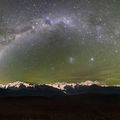
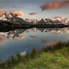
Der verregnete und kühle Sommer 2011 wurde in Mitteleuropa durch eine stationäre Troglage verursacht. Die normalerweise langsam um den Globus ziehende und dabei Nord-Süd mäandrierende Höhenströmung der mittleren Breiten blockierte und kam zum Stillstand. Die kühle, wolkenreiche Polarluft verblieb über Mitteleuropa. Entlang dieser Höhenströmung zogen unzählige Tiefdruckgebiete nach Europa. Am Südrand dieses stationären Trogs, zumeist in den Südalpen gelegen, wechselten sich dadurch wiederholt streifende Frontdurchgänge mit schwachen Hochdruckbrücken ab. Dies sorgte für wechselhaftes Wetter mit häufigen Föhnlagen als Vorboten des nächsten Tiefs, verbunden mit Sturmwinden über den Bergen. Häufig kam es in Folge zu Kaltfrontgewittern mit Starkregen und dekorativem Neuschnee in den Bergen. Solch instabile Wetterlagen bieten dramatische Wolkenstimmungen aber auch starken Wind, der keine Spiegelungen zulässt. Zudem sind die bis zu 4810 m hohen Berggipfel des Mt. Blanc Massivs unter diesen Bedingungen zumeist in Wolken verhüllt. Daher braucht es einigen Aufwand, das tief verschneite sommerliche Gebirge in solcher Lichtstimmung gespiegelt im See vorzufinden.
August2011
Canon 5D MkII, Canon L 16-35 mm, f/16, 4 Sek, 100 ASA, Lee GND, Stativ
Mehr Information:
http://www.lichtjahre.eu
Where Geoscience Meets Art
------------------------
The rainy and chilly central European summer of 2011 was caused by a stationary through situation. The upper air stream of the mid latitudes usually moves slowly from west to east by meandering around the globe. This year a blocking situation stopped the movement and the trough was situated just over Europe. Numerous low pressure systems developed within the associated cold and cloudy air of polar origin. The southern border of the trough was most often located in the area of the Southern Alps causing frequently changing weather of moving fronts and weak high pressure ridges. Often orographic foehn clouds appeared in connection with high wind speeds over the mountains as precursors for rainy weather. Cold fronts caused thunderstorms with intense convective rainfall and fresh snow on the high peaks. Such instable weather produces dramatic cloud decks but also high wind speeds that destroy lake reflections. Additionally the moisture causes the 15780 ft (4810 m) high Mt. Blanc massif to hide in convective clouds for most of the time. Some time and effort is needed to photograph the snowy massif at low light conditions including a perfect reflection in the lake.
August2011
Canon 5D MkII, Canon L 16-35 mm, f/16, 4 sec, ISO 100, Lee GND, tripod
More information:
http://www.lichtjahre.eu
Where Geoscience Meets Art
Commentaire
98


Information
| Section | Natur: Bergseen |
| Vu de | 28 229 |
| Publiée | |
| Langue |

|
| Licence |
Plébiscité par


Favoris publics


Copier la photo
Insère le lien suivant dans un commentaire, une description ou un message pour montrer cette image.
Copier le lien...
Clique, STP, sur le lien et utilise la combinaison de touches "Ctrl C" [Win] ou "Cmd C" le [Mac] autour du lien à copier.
Partager sur Messenger
Insérez le lien suivant dans le champ de commentaire de la conversation désirée dans Messenger en utilisant 'Coller' pour envoyer cette image dans le message.
Copier le lien...
Clique, STP, sur le lien et utilise la combinaison de touches "Ctrl C" [Win] ou "Cmd C" le [Mac] autour du lien à copier.
landscapephoto18 03/09/2016 17:57
Hallo Christian!Dieses Bild ist wirklich fantastisch! Der Aufwand war sicher sehr groß, allerdings hat sich die Mühe aus meiner Sicht gelohnt. Gratuliere.
Lg Daniel
Frank911 23/11/2012 16:16
Zurecht in der Galerie.Ganz ganz toll.
Grüße
LindaKristinK. 01/03/2012 17:54
Der Aufwand hat sich gelohnt. Ein wirklich besonderes Bild mit einer eindrucksvollen Farbkombination. So sommerlich grünes Gras sieht man selten mit so viel Schnee zusammen ;-)LG Linda
Michaela St 10/12/2011 11:55
Meine Güte ist das schön :-) Wollte nie in die Berge aber ich glaub ich denke doch noch mal drüber nach :)Prantl Christian 09/12/2011 17:16
Hallo Christian deine Landschaften Fotos sind Super GutGruss Christian Prantl
Birgit Simone 23/11/2011 9:32
Traumhaft schön!!!Lg Birgit
Mirko Vecernik 28/09/2011 20:33
Dieses Bild reiht sich nahtlos in dein exquisites Portfolio ein!LG Mirko
Heidi Schneider 07/09/2011 14:24
Wirkungsvoll. Stechend scharf, fast etwas unheimlich. Ich würde weniger Himmel sehen wollen oder weniger gras (und mehr Himmel) Das heisst: Motiv und Bearbeitung mag ich, Komposition weniger.Vera Laake 06/09/2011 14:15 Commentaire de vote
***PRO***Matthias von Schramm 06/09/2011 14:15 Commentaire de vote
das ist nicht so gut cMatthias Pöltl 06/09/2011 14:15 Commentaire de vote
cHagen H. 06/09/2011 14:15 Commentaire de vote
+Arno M 06/09/2011 14:15 Commentaire de vote
cChrista Kramer 06/09/2011 14:15 Commentaire de vote
Das ist ein perfektes Naturschauspiel und wenn da noch einer sagt, da läuft der See aus, dann muss er dringend zum Augenarzt!************************PRO*******************************
Frank911 06/09/2011 14:15 Commentaire de vote
WOW!!Tolle Lichtstimmung.
PRO