

Westlothian Landscape
9/12/2022
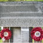
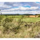
On the way from the Shotti-Korean war memorial, commemorating more than a thousand fallen Scottish soldiers, the forest mostly extends to the right-hand side of the road, while to the left of the road there are repeated views over the meadows, pastures, fields and forests of the gently rolling landscape Lothians surrender.
There are almost never footpaths along these country roads; so always walk on the side of oncoming traffic. Before tight curves and hills (blind summit), however, it is better to go to the outside of the curve or with the traffic. This is how you get safely along the country road, even if the constant changes are annoying.
According to information and interesting pictures on Google Maps, there should be an old ruin and a stone setting on the site of Aitken Farm. At first I found the farm deserted and no one appeared when I called. In the large stables there were numerous cows in their boxes. There, where the marking for the stones showed in Google Maps, there was a pasture whose gate was only secured with a rope. So let's see! In the middle of the pasture was a bush on a hill. When I got there I spotted a loose bull and carefully backed away. Then an oncoming jeep drove through the stables and I followed it. In a house behind the stables I met the farmer's wife who explained to me (as did other residents later) that there were no such buildings and stones on her railing and in the surrounding area. In the meantime, the "sight" has disappeared from Maps, but a newly attached 360° image shows a ruin in the distance.
My path continued to Cockleroy Hill, just before Linlithgow...
Die Landschaft Westlothians
Auf dem Weg vom shottisch-koreanischen Kriegsdenkmal, zum Andenken an über tausend gefallene schottische Soldaten, reicht der Wald überwiegend bis an den rechten Straßenrand heran, während sich links der Straße immer wieder Ausblicke über die Wiesen, Weiden, Felder und Wälder der sanft geschwungenen Landschaft Lothians ergeben.
Fußwege gibt es am Rand dieser Landstraßen fast nie; also immer auf der Seite des Gegenverkehrs gehen. Vor engen Kurven und Anhöhen (blind summit) aber lieber zur Kurvenaußenseite bzw. mit dem Verkehr gehen. So kommt man heil entlang der Landstraße, auch wenn die ständigen Wechsel nerven.
Auf dem Gelände der Aitken Farm sollte sich laut Infos und interessanten Bildern auf Google Maps eine alte Ruine und eine Steinsetzung befinden. Die Farm fand ich zunächst menschenleer vor und auch auf mein Rufen erschien niemand. In den großen Stallungen befanden sich zahlreiche Kühe in ihren Boxen. Dort, wo sich in Google Maps die Markierung für die Steine zeigte, befand sich eine Weide, deren Gatter nur mit einem Seil gesichert war. Also mal schauen! In der Mitte der Weide befand sich ein Gebüsch auf einer Anhöhe. Als ich dort ankam entdeckte ich einen frei laufenden Bullen und zog mich vorsichtig zurück. Dann fuhr ein ankommender Jeep durch die Stallungen und ich folgte ihm. In einem Haus hinter den Stallungen traf ich auf die Farmersfrau, die mir (ebenso wie später andere Anwohner) erklärte, dass es solche Gebäude und Steine auf ihrem Geländer und der näheren Umgebung nicht gäbe. Mittlerweile ist die "Sehenswürdigkeit" aus Maps verschwunden, aber ein neu anghängtes 360°-Bild zeigt in der Ferne eine Ruine.
Mein Weg führte mich weiter zum Cockleroy Hill, kurz vor Linlithgow...
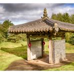
Scottish Korean War Memorial
Manuel Gloger
Scottish Korean War Memorial Information Board
Manuel Gloger
Commentaire
6


Information
| Sections | Voyage: Edinburgh and Lothians Natur: Äcker, Felder & Wiesen Natur: Kulturlandschaften |
| Vu de | 4 744 |
| Publiée | |
| Langue |

|
| Licence |
Exif
| APN | NIKON D500 |
| Objectif | AF-S DX VR Zoom-Nikkor 18-105mm f/3.5-5.6G ED |
| Ouverture | 9 |
| Temps de pose | 1/160 |
| Focale | 18.0 mm |
| ISO | 125 |
Plébiscité par


Copier la photo
Insère le lien suivant dans un commentaire, une description ou un message pour montrer cette image.
Copier le lien...
Clique, STP, sur le lien et utilise la combinaison de touches "Ctrl C" [Win] ou "Cmd C" le [Mac] autour du lien à copier.
Partager sur Messenger
Insérez le lien suivant dans le champ de commentaire de la conversation désirée dans Messenger en utilisant 'Coller' pour envoyer cette image dans le message.
Copier le lien...
Clique, STP, sur le lien et utilise la combinaison de touches "Ctrl C" [Win] ou "Cmd C" le [Mac] autour du lien à copier.
Anne Berger 16/06/2023 14:19
Besucher sind hier wohl nicht so erwünscht im sonst gastfreundlichen Schottland. Ein schöner Blick in diese Landschaft und mir gefällt auch der Einbezug der Trockenmauer.LG Anne
Stefan Jo Fuchs 16/06/2023 7:00
Schottland sanft und lieblich, aber nicht minder schön.Sehr schöne Eindrücke von diesem eher unbekannteren Landstrich zeigst du uns, die zeigen: überall hat Schottland Schönheit zu bieten.
lg stefan
Gerd Frey 15/06/2023 20:15
Du zeigst eine schöne Idylle.LG Gerd
Vitória Castelo Santos 15/06/2023 17:13
Prima aufgenommenen - sehr gute PerspektiveLG Vitoria
LichtSchattenSucher 15/06/2023 14:35
Schöner Blick über die schottische Kulturlandschaft!Und guter Erlebnisbericht...
Gruss
Roland
Joachim Irelandeddie 15/06/2023 10:44
Eine sehr gelungene Aufnahme die du hier von der Landschaft gemacht hast. Der ausführliche Bericht zu deiner Aufnahme liest sich ja so richtig spannend. Das sind dann so die besonderen Erlebnisse die man bei so einer Reise hat!LG eddie